
When you embark on a sand and gravel project, it is to your advantage to know the business, even if a commercial developer is actually carrying out the work. There are seven stages of activity:
- exploration;
- regulatory approvals;
- financing;
- site preparation;
- extraction;
- processing;
- and site rehabilitation.
It is usually the project developer who assumes responsibility for these tasks and who undertakes to start and run the business. Without a developer, there is no project. The developer may be:
- a third party, completely independent of your community;
- a development corporation controlled by a Tribal Enterprise or its members;
- or a joint venture controlled by the Tribal Enterprise and an independent third party.
Whatever the situation, the project developer is considered a separate entity from the Tribal Enterprise, one of the three participants in the project.
Exploration
A broad range of field search and measurement activities are used to gather information about the location, size, quality, type and nature of sand and gravel deposit. The purpose of this exploration is to establish whether the deposit is suitable for development.
How much you spend on exploration will depend on market conditions, project size, value and intended use of the resource. A step-by-step approach is a way to minimize the costs of what can be an expensive undertaking. For example, conducting a detailed testing program over a large area without studying the landscape first to determine which areas have the most potential for sand and gravel deposits would be costly.
Geological exploration is usually conducted in five stages. These are not hard and fast rules, but logical steps through the process. For sand and gravel development, stages I, III, V in particular are often followed.
Stage I: Literature Research Studies and Local Sources
This is a preliminary geological assessment of a prospect and its surrounding area for sand and gravel potential. It is based on a review of available published geological information. Maps or reports on the surficial geology, aggregate resources and past and present gravel pits in the area may show known sand and gravel resources.
Talk to residents and local operators of sand and gravel companies to help identify resources in your area. All this information will focus your search on the most likely locations to check first.
Stage II: Field Surveys
At this stage, a geologist visits the identified sites, reviews local land features, notes which features may have potential and collects information about the areas that look promising.
Possible sites can either be paced off or measured with a distance-measuring device, such as a hipchain, to estimate the size of deposit. Surface evidence of deposits is often found at road cuts or holes dug for foundations. Abandoned or existing pits can also provide clues.
The geologist collects and labels samples of sand and gravel material found at each site for later identification and analysis. The geologist would also plan for the next phase, including equipment needed, access to potential areas, scheduling of work and meeting with the Tribal Council to keep them informed of work completed and results, and the direction of future work.
Stage III: Geoscientific Studies
If the field surveys are positive, the next step is a closer examination of the most promising sites. Techniques include geological mapping, test pitting and sampling, and more detailed geophysical surveys to determine the location, volume, extent and quality of sand and gravel deposits on your reserve. The purpose is to focus on smaller areas to collect information on the deposits. As the need for more information increases, so does the cost of the study.
To carry out a detailed testing program, the developer's first step is to identify the equipment needed. A backhoe is adequate for digging test pits 10 to fifteen feet deep.
For thicker deposits, a truck-mounted auger or Becker drill with the capacity to drill 40 to 50 feet is used. Choice of equipment is also influenced by other factors such as accessibility to the area and the presence of trees or crops. After finding and pricing equipment, the developer arranges for rentals and operators, schedules the work and decides the sites to be tested. At this point, the developer also will have chosen a laboratory to analyze the samples.
Of the many exploration techniques used, test pitting, geophysical surveys and geological mapping are the most common for sand and gravel exploration.
Test Pitting: In this survey method, a grid pattern is laid out over the potential sand and gravel deposit. Straight lines equally spaced, separated by measured distances and intersecting at 90-degree angles are brushed or staked over the potential deposit.
For example, two test pits, A and B, are dug 300 feet apart. Since both contain sand and gravel, it is assumed that the material is consistent between the two pits. Two other test pits, C and D, are dug. The new pits are 300 feet apart. If all the test pits show sand and gravel, it is assumed that the entire area, 300 feet by 300 feet contains sand and gravel.
Test pit E is excavated but no sand and gravel are found. This means the gravel deposit ends somewhere between B and E. It can be assumed the gravel material stops halfway, or in this case, 150 feet from B. This process is repeated in the test area until the outline of the gravel deposits is determined. If the deposit is suspected to be very large, the distance between the test pits can be increased up to 1600 feet.
Once the outline of the deposit is completed, the volume of the deposit is calculated using the thickness of the sand and gravel found in the test pits.
At each test pit where significant sand and gravel are found, a 100 to 150 pound sample is collected, labelled and sent to the laboratory. The lab tests identify the quality, characteristics and suitability of the material for various uses.
Geophysical Surveys: Often used in combination with test pitting, geophysical surveys use electronic instruments to measure the characteristics of the underlying sand and gravel without digging holes.
The principal methods are seismic and electromagnetic (EM). Seismic systems use sound waves to measure the thickness and depth of different components of the material beneath the surface.
EM uses invisible electromagnetic properties of the rocks to determine the kind of material. Using grids in much the same way as in test pitting, the geologist can cover larger areas with these methods.
Geological Mapping: A map is drawn of the location of the sand and gravel deposit with the grid showing the location of the pits, the outline of the deposit and the results of the geophysical surveys.
Measurements of a deposit's thickness, descriptions of the material and the results of later sample analysis will give the total volume and quality.
Once the analysis is complete, the geologist prepares a summary report on each site. The results of these surveys will be the basis for your decision to proceed with further assessment, or to prepare a plan for extraction.
Stage IV: Test Drilling
In rare situations, test drilling is needed to determine the depth or area of a deposit. In such cases, a few holes are drilled using specialized and more expensive equipment, such as a Becker hammer drill, one of the few drills capable of penetrating gravel. In most cases, however, the completion of a detailed site investigation provides enough information to begin developing the deposit.
If you are considering a quarry operation, detailed test drilling is necessary to determine the quality, quantity, blast patterns and crushing characteristics of the bedrock. A quarry would usually be developed in limestone, dolomite or granite.
Stage V: Market/Feasibility Studies
The final stage of exploration looks at the local market conditions, current and future demand, prices and all the engineering and equipment necessary for the start-up of a new operation. Although a formal market or feasibility study could cost as much as $50,000, it provides crucial information to help the developer decide whether to make a major financial commitment to proceed.
For small operations, the feasibility study would look at specific needs and buyers and would probably be limited to the specific application. Very small projects may be able to rely on informal surveys and knowledge of local conditions.
Regulatory Approvals
The project developers are responsible for securing all necessary regulatory approvals. They cannot work on tribal trust land without the consent of the Tribal Enterprise, a permit from the Bureau Indian Affairs and and a completed environmental assessment. The cost of security regulatory approval is a factor in project budgets. These costs vary depending on the size of a project, but normally they range from one to five percent of the total project cost.
Financing
Since project developers usually incur costs for exploration, regulatory approval, equipment and site preparation well before revenues from sales begin to come in, project financing comes early in the development process. The following table outlines the estimated costs associated with the development of various sizes of projects.
|
Phase |
Estimated Costs |
|
Exploration Research (Stage I) |
$10,000 |
|
Field Surveys (Stage II) |
$30,000 |
|
Geoscientific Studies (Stage III) |
$10,000 |
|
Test drilling (Stage IV) |
$35,000 |
|
Feasibility studies (Stage V) |
$50,000 |
|
Development |
$10,000 |
|
Rehabilitation |
$10,000 |
|
Total |
$155,000 with drilling |
There are a variety of financing arrangements open to developers including renting or leasing equipment to reduce initial capital costs.
Site Preparation
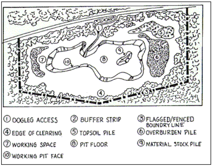 Developing a pit site takes time and money. From the very beginning, the pit should be well designed for safe and efficient operation;
When designing a pit, consider the following:
- Trees cleared from the site can be used for local building or sold as firewood; stumps and brush may be burned or mulched.
- Topsoil is a valuable commodity to be saved for the land restoration process. Standard procedure is to scrape off and stockpile soil close to the site.
- Overburden is unwanted material on top of sand and gravel, such as glacial sands, clays and peat, which must be pushed or scraped off and stockpiled before excavation can begin. This material is also used in the restoration process. If the overburden is more than five feet thick, it may be too costly to remove.
- The location of stockpiles is very important. The developer does not want to have to move an overburden or topsoil stockpile at great expense because it is located over another part of the deposit where future extraction is supposed to begin.
- The developer may have to build a system of culvert pipes, ditches and collection pools to drain surface runoff and prevent erosion.
- Fences and gates around the pit will discourage trespassers, livestock, garbage dumping and theft. Their presence could also be a factor in helping to protect the developer in any legal actions that might arise out of an accident.
- For privacy and safety, the pit and access roads should not be visible from public roads.
Extraction
Backhoes, front-end loaders and bulldozers can usually dig out the sand and gravel material directly from the working face of the pit.
Because of the instability of sand and gravel, the pit face should never be allowed to get higher than 20 to 25 feet for safe extraction. For deposits of 65 to 100 feet, benches or steps are often used; this approach, called "benching," is not only safer, it also permits easier and less expensive restoration of the land after the pit is closed. Pit floors are best kept flat and reasonably clear of holes to maintain drainage and minimize waste. The pit floor should be graded, or sloped slightly away from the pit face, to allow water to drain away. Generally, extraction is stopped once the water table is reached because going deeper can cause major drainage problems. A pit can become a lake very quickly.
Water passes through sand and gravel. Whatever spills onto the pit floor, fuel and oil from heavy equipment for example, leaks very quickly into the ground water, contaminating water and wells in the surrounding area.
The discharge of muddy or silty water from an extraction site is strictly regulated by federal and state authorities because of the potential danger to fish habitats and spawning grounds in nearby creeks and rivers.
Processing
Natural sand and gravel can be used for many purposes, but to meet the specific needs of some customers, processing is necessary. Processing is a highly developed procedure requiring special skills and expensive equipment to screen, crush, sort, wash and stockpile the material. A gravel operation can make between five and 10 different products.
Processing usually follows these steps.
- A truck or front-end loader dumps raw gravel from the pit into a hopper where the largest rocks (usually greater than 10 inches in diameter) are screened out.
- Conveyor belts carry a continuous stream of material through crushers which break up the stones and screen the material by grain size. The bigger chunks are stockpiled for reprocessing.
- If a deposit contains too much silt, a wash plant using water jets will remove it, or reduce it.
- A series of conveyor belts carries processed sand and gravel products to a storage pile or loads it directly onto trucks.
The initial capital cost of a sand and gravel business is high, but the purchase of a processing plant can be spread over many years. To make this kind of investment worthwhile, at least one large deposit of sand and gravel and a good, long-term market are necessary.
As an alternative, a developer might contract out the crushing and screening tasks. This would allow a new business to focus on the local market and the quality control of a product, a requirement necessary to meet the high standards set by many customers.
Site Rehabilitation
Planning for the rehabilitation of a pit during the early development stage will make the restoration process easier. Ugly, abandoned pits affect the area's appearance, productivity and safety for generations. Restoration, which is the developer's responsibility, is now a routine cost of doing business. A reputable company will carry out ongoing restoration, instead of waiting until operations finish.
- Slope reduction is usually the first step in pit rehabilitation. Gravel pits often end up with very unstable and steep, almost vertical work faces. To lessen the risk of landslides and injuries, and to minimize erosion from surface runoff, these faces are reduced to gentler grades.
- Flatter inclines also permit the seeding and growth of plants and are more suitable to other forms of land use. The maximum acceptable slope in the restoration of a pit is a ratio of one vertical to three horizontal (33 percent grade). This means that for every foot of height there should be 3 feet of distance from the bottom of the working face.
- All garbage, supplies and equipment are taken from the site. Pits should not be used for the disposal of domestic, industrial or toxic waste because of the porous quality of sand and gravel and the potential for contaminating ground water.
- The stockpiled topsoil and overburden are spread over the site to encourage revegetation.
- Whether the developer is responsible for seeding or further landscaping of the site depends on the original agreement.
- Before development even begins, the Tribe could plan the end use of the land. For instance, your community may want to landscape or seed the rehabilitated land or use the site for housing, a sports park or commercial development.
Reference: http://collectionscanada.gc.ca/eppp-archive/100/200/301/inac-ainc/building_future-e/snd/sgb_e.html