
During the spring of 2023, the Sierra-Nevada Mountains along the California/Nevada border received very high snowpacks which created a long duration flood event that only occurs once in five hundred years in the Walker River basin. BIA was required to release water through the Weber Reservoir throughout the long event. This created erosion of the Walker River riverbanks downriver from the Dam and forced the BIA Western Nevada Agency office, the Yerington Paiute and Walker River Tribes, the State of Nevada, and all the affected towns and governments to take action to prepare for flood activities. Sandbags were placed and prepositioned, along with water, rock gabions, and other material necessary for redirecting water flows.
An inspection of the Dam in May 2023 revealed open and offset joints between the Dam’s service spillway slabs and sediment in the service spillway drains, early indications the soil under the service spillway chute may be experiencing erosion. On May 17, 2023, the BIA Superintendent, Western Nevada Agency in Carson City, Nevada issued a Level 1 Response Notice at Weber Dam due to a slowly developing and unusual situation that could have potentially progressed into a life-threatening event. On, August 4, 2023, the Western Nevada Agency lifted the Level 1 Response Notice because the potential for an emergency had passed.
The gates of the service spillway closed the evening of August 4th, and the reservoir operations returned to their normal seasonal functioning to allow regular uninterrupted irrigation use.
About Weber Dam
Weber Dam is in southwest Nevada, approximately 132 miles southeast of Carson City, Nevada. The dam is located within the Walker River Indian Reservation, approximately 10 river miles northwest of the town of Schurz, and approximately 28 river miles northwest of Walker Lake. Inflow to Weber Reservoir is from the Walker River, a stream which begins in the Sierra Nevada Mountains, and ends at Walker Lake. Walker Lake is a natural lake with no outlet. Weber Dam and reservoir are operated by the Bureau of Indian Affairs (BIA). Reservoir storage provides summer irrigation and recreation benefits to the Walker River Paiute Indian Reservation. The reservoir capacity at the active conservation water surface, elevation 4208.0 (top of spillway gates), is 10,720 acre-feet. The reservoir typically is operated near full pool year-round.
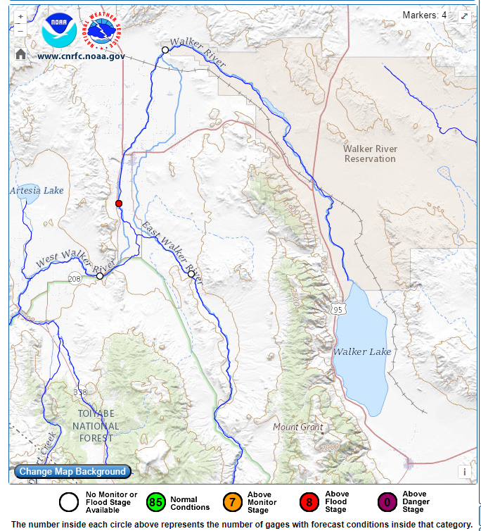
Walker Basin Hydro Mapper
The Walker Basin Hydro Mapper provides a basin-wide perspective of rea-0time streamflow and reservoir storage capacity for the Walker River Basin in Nevada and California. The tool was developed to create a common operating picture for water users in the Walker River Basin and to help monitor changes to instream flows.
The interactive map shows data from USGS stream, lake, and atmospheric stations and Natural Resources Conservation Service (NRCS) SNOTEL stations as well as current weather conditions. Lake and reservoir stages and storage data along with descriptive information is provided for Bridgeport Reservoir, Topaz Lake, Weber Reservoir, and Walker Lake. Historical and most recent water-quality profiles and total dissolved solids concentrations for Walker Lake are also provided.
Weber Dam Response Level
On May 17, 2023, the Bureau of Indian Affairs Superintendent, Western Nevada Agency in Carson City, Nevada issued a Level 1 Response Notice at Weber Dam due to a slowly developing and unusual situation at Weber Dam that could potentially progress into a life-threatening event. On August 4, 2023, the Western Nevada Agency announced it is lifting the Level 1 Response Notice because the potential for the emergency has passed.
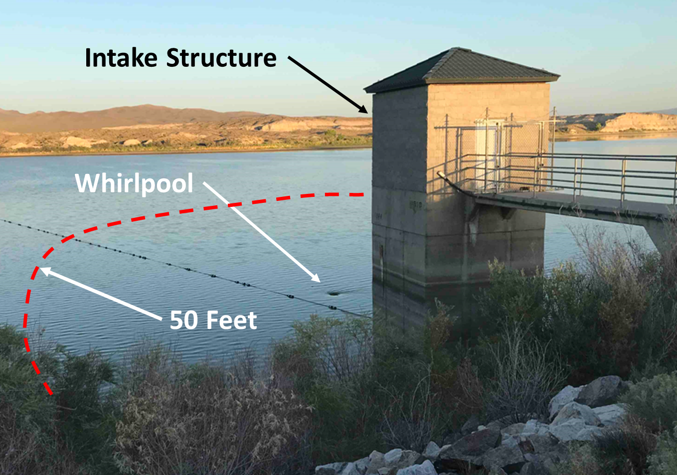
Local recreationalists using Weber Reservoir are advised to stay at least 50 feet from the intake structure (see photo) as dangerous currents and whirlpools are known to exist in this area and are very dangerous to swimmers and individuals in small watercraft (tubes, air flotations, kayaks, canoes, and paddleboards).
Construction Activity Timeline
An inspection of the Dam in May 2023 revealed open and offset joints between the Dam’s service spillway slabs and sediment in the service spillway drains, early indications the soil under the service spillway chute may be experiencing erosion. Out of an abundance of caution, engineers and scientists from BIA’s Safety of Dam’s Program took proactive measures to provide for public safety and to protect the structural integrity of the Weber Dam facility.
Timeline of Measures taken to improve the functionality of the emergency spillway in the event the reservoir overflowed:
- May 17th, the BIA Superintendent, Western Nevada Agency in Carson City, Nevada declared a Level 1 Response at Weber Dam.
- June 15, BIA awarded a contract to Chiricahua Procurement LLC, a company based in Albuquerque, NM to provide heavy equipment, rock, and gravel to Weber Dam.
- June 21, BIA proactively started moving rock riprap, gravel, and construction equipment to the site in the event action needs to be taken to slow erosion of the service spillway chute foundation.
- June 26 – Completed the removal of the Weber Dam Fuse Plug, which was overseen by a BIA Civil Engineer (Construction Specialist).
- The fuse plug is a rock embankment feature of the emergency spillway intended to wash out in a predictable manner to lower the water elevation of the reservoir should it exceed its holding capacity.
- Removing the fuse plug reduces the worst case downstream flood potential scenario by 50%.
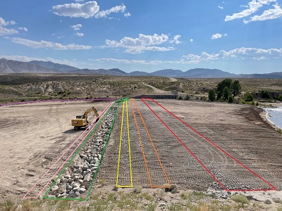
- June 28 – Constructed two erosion cutoff trenches downstream from the salvaged riprap of the fuse plug.
- Cutoff trenches are an engineering featured installed to help slow and or stop erosion.
- The salvaged riprap consisted of small rock and gravel.
- Installed and improved a two foot berm to assist in keeping flow out of the fishway channel.
- July 7 – Completed the construction of a 3rd erosion cutoff trench approximately 8 feet deep by 8 feet wide using imported 36” riprap. This larger riprap is intended to stop erosion.
- July 10 – Started construction of last erosion cutoff trench approximately 4 feet by 4 feet using imported 36” riprap.
- July 14 - Completion of the last erosion cutoff trench.
Key Messages
Key messages are released for the purpose of handing out key factual information to community members. These are updated when necessary.
June 14 WRPT Community Meeting
On June 14, Bureau of Indian Affairs Safety of Dams and Western Nevada Agency staff provided a visual presentation about Weber Dam. The presentation highlighted the components of the dam and actions the Bureau is taking following the early detection of erosion under the service spillway joints.
During the community meeting, Walker River Paiute Tribe's Emergency Management Incident Commander, cooperators from the Nevada Division of Emergency Management, and the Federal Emergency Management Agency shared key information and actions being taken to prepare the Schultz community for flooding that could reach as high of level as 5,000 cubic feet per second.
Additional Information
Additional Resources
- Walker River Paiute Tribe Water Resource Department
- Walker River Paiute Tribe Facebook
- Nevada DEM Flood Information
- Nevada 511 Road Conditions
- NV Energy Power Outages
Related Documents
- weberdamresponse_keymessages_june_16_final.pdf (325.59 KB)
- june_23.pdf (335.44 KB)
- june_26_2.pdf (338.82 KB)
- Public Safety Advisory - Weber Reservoir (231.03 KB)
- June 29 Key Messages (470.14 KB)
- July 5 Key Messages (334.99 KB)
- Key messages July 13 (564.67 KB)
- July 19 Key Messages (339.98 KB)
- Response Level 1 Lifted (361.82 KB)
Contact Us
Carson City,, NV 89701-4065