
You are viewing ARCHIVED content published online before January 20, 2025. Please note that this content is NOT UPDATED, and links may not work. Additionally, any previously issued diversity, equity, inclusion or gender-related guidance on this webpage should be considered rescinded.
Announcement
Author: Lessa Peter
The Hualapai (People of the Tall Pine) Tribe is in northwest Arizona with a land base that encompasses over a million acres. The land has four primary fuel types: timber – Ponderosa Pine, woodland – Pinyon and Juniper, grassland – sage, and riparian – Cottonwood and Salt Cedar. In FY2022, $1,898,187 of the Bipartisan Infrastructure Law (BIL) funding, amounting to approximately $1.85 per acre, was granted to the Tribe for a 5-year project called Jump Start. The project is using Light Detection and Ranging (LiDAR) technology to capture 3D imagery of the Tribe’s vegetation, infrastructure, watersheds, and overall land to help the Tribe with numerous current and future land management and use projects.
High-resolution LiDAR (20ppm) data was collected over the Hualapai Reservation between October and November 2022 along with simultaneous 12-inch resolution color imagery. The data collection was accomplished by the contract awardee, Northwest Management, Inc., using a 3 fixed-wing aircraft in coordination with the Hualapai airfield personnel and natural resource teams. The analyses applied to these data will yield a virtual/digital twin of the entire landscape including roads, streams, forest inventory, woodland inventories, and fire risk maps. These tools are inclusive of real-time market and resource condition information and supported by field data calibration of all the remotely sensed layers.
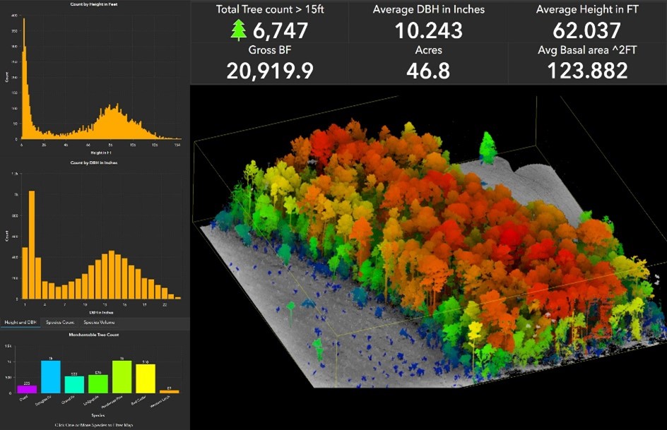
Pictured above: 2022, 3D color LiDAR capture of a tree stand provided by Northwest Management, Inc.
When the LiDAR data is received this spring, the Tribe’s Forestry and Wildland Fire Management staff will use the data to identify stand density (volume/diameter distribution), ecotones, and updates on vegetated acreage. The data will dictate project type and priority for each Forest Development, Timber, and Hazardous Fuels Reduction program. It will further provide Wildland Fire Management with the ability to identify acreage at high-risk of wildfire and support strategic planning from the perspective of fire spread/containment and efficient resource use planning and preparedness.
“LiDAR allows us to analyze data for one acre out of more than a million and provides the identity of a single tree. The single tree data will expand to a stand and through all fuel types up to the boundaries of the Hualapai Reservation, ” stated Hualapai Tribal Director of Forestry & Wildland Fire Management Melvin Hunter, Jr. “LiDAR data captures the fuel type between Continued Forest Inventory (CFI) plots improving from a representation to near actual data providing forest measurements.
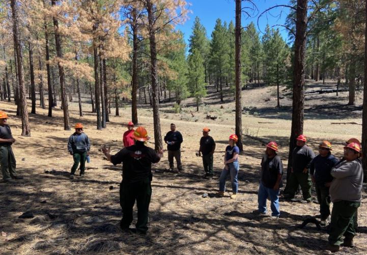
Pictured above: Hualapai staff receive education about land that has received prescribed burn treatments on the reservation.
Interest in LiDAR grew within the Hualapai Tribe as a collaborative effort in discussing technology use to benefit the Tribe and included other non-natural resource teams such as Public Works, Cultural Resources, and Tribal leadership. Projects identified by the Tribe include range unit restorations to increase grazeland for cattle, recreational use for Tribal members, identifying possible burial sites using mineralization maps, and road development within the reservation. The Tribe’s Department of Natural Resources provided insightful perspectives in bringing these teams of varying interests together to gain informed decisions on the use and potential applications of new technology to support multiple objectives for the Hualapai Tribe.
“We are pleased to have the continued support from Hualapai tribal council, Bureau of Indian Affairs (BIA) Western Region, BIA Division of Wildland Fire Management, and Northwest Management, Inc. We are all looking forward to the data and tools to be provided as well as our ideas of what to expect. We also realize this technology offers opportunities and collaborations beyond what we currently see, and the Hualapai Tribe is eager to explore and grow these.”
 2022 3D color LiDAR capture of a tree stand provided by Northwest Management, Inc.
Contact Us
Open 8:30 a.m.–4:30 p.m., Monday–Friday.