
You are viewing ARCHIVED content published online before January 20, 2025. Please note that this content is NOT UPDATED, and links may not work. Additionally, any previously issued diversity, equity, inclusion or gender-related guidance on this webpage should be considered rescinded.
Author: Robyn Broyles
On June 15, 2016 the Cedar Fire started on Fort Apache Indian Reservation, southwest of Show Low, Arizona. Nearly 72 square miles of invaluable resources burned before the fire was finally contained on July 1, 2016.
Left in its wake were homes, churches, a cemetery, a school, and a sewer lagoon at risk of post fire damages. Cultural resources, wildlife and soil were also at risk of erosion, flooding and habitat loss.
To prevent further damage, the Bureau of Indian Affairs at Fort Apache Agency made a request to have an Interagency Burned Area Emergency Response (BAER) Team conduct a post-fire evaluation to provide flood mitigation recommendations. On June 19, experienced resource specialists began making assessments that would lead to an emergency response plan impacted communities could use in the event of post fire flooding. To assist in these assessments, resources specialists take a satellite image of the burned area and lay it over the top of a digitized map and begin collecting information that helps them ground-truth the image for accuracy.
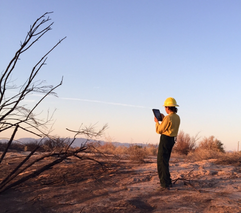
Juliette Jeanne captures documentation on the Willow Fire using an iPad and Collector App. Photo by Tina Johnson.
One tool specialists are using with more frequency to help collect, verify and correct field data is an app called ArcGIS Collector. The app allows users to download maps to portable devices, like an iPad, and take it to the field where it can be used without internet connectivity.
Users may geo-reference data points and add associate photos, videos and notes about that point. When users return from the field, their new data is automatically uploaded to maps in their work environment where they can be shared among all users.
The rapid access and sharing capability is improving the Team’s efficiency and creating shared understanding and consistency.
For BIA, another advantage to this technology is that Agency Administrators have access to timely data that gives them critical information needed to make informed and timely decisions. This saves time, money and even the resources that may be at risk.
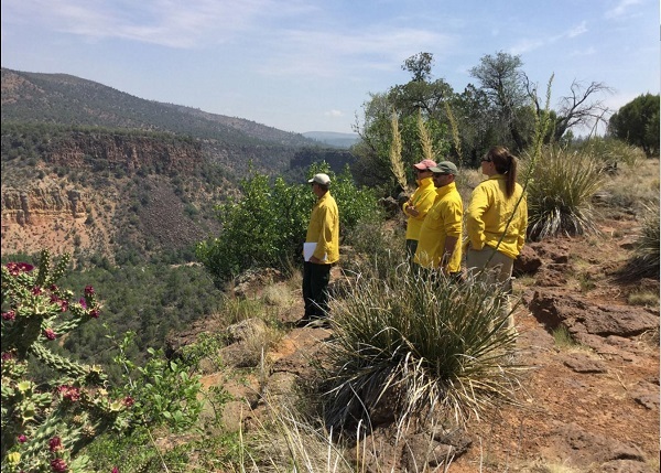
Cedar Fire BAER Team members conduct field surveys of the burn area. Photo BIA.
Pulling it together using Story Map Journals
After the BAER Team completes their assessments and develops an emergency response plan, a closeout with the Agency and Tribe takes place to present the Team’s findings and recommendations.
To communicate a more comprehensive picture, the Team employs another ArcGIS tool - Story Map Journal.
The Story Map incorporates narrative text with maps, pictures, video, web links and other embedded content to create interactive “journal pages” that are easily to read and interpret.
Trisha Johnson, BAER GIS Analyst and Technical Specialist, uses the Story Map Journals as a way to present in-depth information about the Team’s work.
For the Cedar Fire Story Map, Johnson used a variety of tools to tell the story of how the fire progressed and the work the Team accomplished during their assessment.
Journal pages show the Fire’s progress in animated form. Another entry illustrates different degrees of tree mortality across the fire area. Associated with certain point are pictures of the burned area to better illustrate the burn severity. Another entry includes video of a mud flow occurring after recent rain.
These interactive features capture the true magnitude of post-fire effects and bring to life the story of a fire. In so doing, the Journal is helping to put into context key decisions that viewers can understand and see across time.
An additional benefit of the Story Map Journals the accessibility via social media feeds. Journals can be imbedded into web pages, and shared to social media sites, making access to and sharing of the Journal quick and easy.
Future Possibilities
The ultimate goal for the Story Map Journals is to leave a product the local agency can maintain so changes can be documented and monitored through time.
To achieve this, the Team trains local unit personnel during the incident so they have the knowledge and skills to update pages. In time, as agencies and Tribes become familiar with the Collector App and the Story Map Journal, the products will become less of a snapshot in time and more of a living, visual document that assists with planning and decision making.
To see two Story Map Journals currently in use, visit the BIA’s Burned area Emergency Response page
For Immediate Release: January 1, 2018